
Map My Distance
Feature-Rich Route Planning Platform for Map My Distance
We built Map My Distance, a route planning platform with Mapbox maps, elevation profiles, saved routes, POIs, collaboration, and subscriptions.
Client:
Services:
Project Overview
Map My Distance needed more than a simple distance calculator. The goal was to create a modern, scalable route planning platform where runners, walkers, cyclists, hikers, and event organizers could plan, save, share, and discover routes with ease.
We handled the full process from planning and feature strategy through to site design, development, user accounts, subscriptions, route tools, collaboration features, and public route discovery. The result is a powerful mapping platform built around a smooth user experience, practical route planning tools, and room to grow.
The Brief
Map My Distance started with a clear idea: make it easy for people to draw routes online, calculate distance, understand elevation, save their work, and share routes with others.
But the platform also needed to go further than basic route drawing. It needed account features, Pro subscriptions, public route discovery, collaboration tools, points of interest, event organizer functionality, and a route experience that felt fast and intuitive.
This meant the project required full product thinking, not just website development. We needed to plan the user journeys, design the interface, build the core mapping tools, and create a foundation that could support both free users and paid members.
What We Built
We designed and developed a complete route planning platform with interactive mapping, custom accounts, route management, subscriptions, and advanced Pro features.
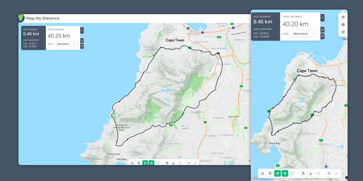
The platform allows users to create routes by clicking waypoints on an interactive Mapbox map. Routes can snap to real roads, close into loops, and show live distance while the user builds. Undo, redo, and draft saving help protect users from losing their work if they refresh the page or leave before saving.
For routes with more terrain detail, Map My Distance includes elevation profiles that show gain, loss, and grade. Points of interest appear on the elevation chart, and the route profile is cached so saved routes load quickly when users return.
We also built a points of interest system, allowing users to mark stops, landmarks, notes, and highlights along a route. Free users can add a limited number of POIs, while Pro users can unlock unlimited POIs, custom icons, colors, photo uploads, and rich text descriptions.
Route Saving, Sharing, and Account Management
A key part of the platform was giving users a reason to create an account and return.
Logged-in users can save routes with a name, activity type, tags, and description. Each route receives a shareable link, making it easy to send routes to friends, clubs, clients, or event participants.
The account area gives users access to their saved routes, recent routes, profile settings, notifications, billing, and subscription information. This creates a more complete product experience and gives Map My Distance a strong foundation for future user engagement.
Public Route Discovery
We also developed a public route discovery experience where users can browse community routes directly on the map.
At wider zoom levels, routes are displayed as markers to keep the map clean and easy to use. As users zoom in, they can view full route lines and access route details. This makes the platform useful not only for planning personal routes, but also for discovering routes created by others.
Event Organizer Program
Map My Distance includes a dedicated Event Organizer program for approved organizers who want to publish public routes.
Organizers can create public route pages with images, descriptions, and external links such as event websites or registration pages. We also built an application and admin review flow, giving the platform control over who can access organizer features.
A dedicated subscription tier was added for organizers, creating a clear path for Map My Distance to support events, races, clubs, and outdoor activity groups.
Pro Collaboration Features
For Pro members, we built route collaboration tools that allow users to invite others to co-edit routes by username or email.
Invitations appear as in-app notifications, and collaborators receive shared access to the route. This makes the platform more useful for teams, friends, event planners, coaches, and groups who need to plan routes together.
Subscriptions and Monetization
Map My Distance includes both free and paid account functionality.
Free users can still use the core route planning tools, build routes, and save their work. MMD Pro unlocks additional features such as an ad-free experience, route collaboration, richer points of interest, and other advanced tools.
Subscriptions are powered through Polar, creating a flexible billing setup for Pro users and the dedicated Event Organizer tier.
Design and Development Approach
The interface needed to feel clean, fast, and practical. Route planning tools can quickly become overwhelming, so the design focused on keeping the main map experience simple while still giving users access to powerful features when they need them.
We planned the product structure, designed the site and application experience, and developed the platform from the ground up. This included the public website, interactive map tools, route saving flows, account area, subscription logic, collaboration system, admin review features, and public route discovery experience.
Every part of the project was built with scalability in mind, allowing Map My Distance to continue adding new tools, user features, organizer options, and future monetization opportunities.
The Result
Map My Distance is now a full-featured route planning platform that goes far beyond a simple map distance calculator.
Users can draw routes, measure distance, understand elevation, add points of interest, save and share routes, discover public routes, collaborate with others, and upgrade to Pro for more advanced tools.
For event organizers, the platform provides a dedicated way to publish rich public routes with images, descriptions, and useful links. For everyday users, it offers a smooth and practical way to plan routes for running, walking, cycling, hiking, and outdoor activities.
From planning and product strategy to design, development, accounts, subscriptions, and advanced mapping features, Kaira handled the full build needed to bring Map My Distance to life.
Project Highlights
- Interactive Mapbox route planning
- Live distance calculation
- Road snapping, loop closing, undo and redo
- Draft route saving
- Terrain-based elevation profiles
- Elevation gain, loss, and grade
- Points of interest with Pro enhancements
- Saved routes and shareable links
- React-powered account area
- Public route discovery map
- Event Organizer application and review flow
- Dedicated organizer subscription tier
- Pro route collaboration
- In-app notifications
- Polar subscription integration
- Free and paid user feature access